


 Erik Bjornstad
How to Winterize a Diesel Engine
Ensure your diesel engine is ready for winter with essential winterization tips for boats and generators to protect your investment and prevent...
Meteorologists are expecting a potentially historic El Niño system could make this coming winter particularly bad across parts of the United States. But what that looks like will depend on where you live,
Quick Answer: What Can We Expect This Winter?
If you've been hearing this coming winter 2026–2027 could be a particularly bad one, there's some reason to pay attention. But that’s not going to mean the same thing for everyone.
Their warnings stem from the possibility of an exceptionally strong El Niño developing in the Pacific Ocean. That kind of system could have a big impact on how winter weather develops across the United States.
The good news is that much of the northern United States could actually experience a relatively mild winter. The bad news is, California, the Southwest, and portions of the South may see more winter storms and snow than normal. Not to mention the growing possibility that colder and snowier weather could develop across parts of the central and eastern United States later in the season, particularly in January and February.
So while the winter might not be unusually cold everywhere, it could still be an unusually disruptive one. Read on and let’s unpack the details.
To understand why forecasters are paying so much attention to this winter, we first need to understand what's happening in the Pacific Ocean. And that means knowing a little more about this thing called El Niño.
El Niño is a naturally occurring climate pattern that develops when ocean temperatures in the central and eastern tropical Pacific become warmer than normal.
In ordinary years, trade winds blow from east to west along the equator, pushing warm surface water toward the western Pacific. But when those winds weaken (part of a natural cycle involving changes in ocean temperatures and atmospheric pressure), more of that warm water spreads eastward across the Pacific.
Now, here's why that matters.
Normally, the warm waters of the western tropical Pacific help produce large areas of tropical thunderstorms. But when unusually warm water spreads farther east during El Niño, more of that thunderstorm activity can develop farther east as well.
As warm ocean water evaporates, the moist air rises and eventually forms clouds and thunderstorms. And when that moisture condenses, it releases heat into the atmosphere.
That concentrated release of heat helps change weather patterns both in the Pacific and in places thousands of miles away. And it can affect the jet streams that steer storms across North America.
During a typical El Niño winter, the southern Pacific jet stream becomes stronger and extends farther east toward the southern United States. Meanwhile, the air north of this Pacific jet stream ends up being milder, which makes for warmer winter temperatures across much of the northern United States.
And that's how we can end up with two very different winter weather patterns across the country.
In the northern states, temperatures are often warmer than normal because these circulation patterns (affected by the shifted jet stream) tend to limit prolonged outbreaks of frigid Arctic air.
But farther south, the stronger jet stream can steer more moisture-laden storms across the country, bringing additional rainfall and, when sufficiently cold air is present, the potential for more snow and ice.
Of course, all this is a simplified explanation. There are other atmospheric patterns at work, and they don't always cooperate with what El Niño would ordinarily lead us to expect. That's part of what makes forecasting winter weather so complicated.
But understanding how El Niño influences these larger weather patterns gives us a starting point for understanding why forecasters are paying so much attention to the strength of this year's event.
It seems like we're hearing about El Niño almost every year. But just how often does it actually happen?
According to the National Oceanic and Atmospheric Administration (NOAA), El Niño occurs approximately every two to seven years. And not every El Niño is created equal. Some are relatively weak, while others become strong enough to have a much greater influence on weather patterns around the world.
For some perspective, the last significant El Niño occurred during the winter of 2023–2024. Before that, we experienced an exceptionally strong event during the winter of 2015–2016, which coincided with some memorable winter storms across the United States.
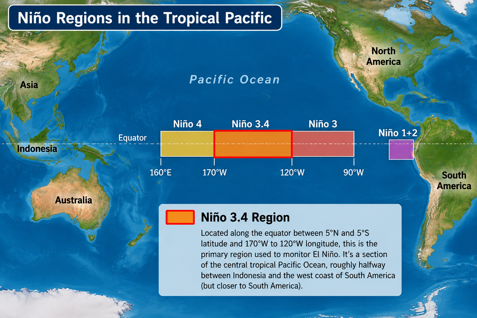
In terms of strong vs. weak, we measure the strength of El Niño by tracking how much warmer than normal the ocean becomes in a particular region of the tropical Pacific - a rectangular region near the Pacific Equator called Nino 3.4. NOAA now uses a measurement called the Relative Oceanic Niño Index, which also accounts for warming across the tropical oceans as a whole. Generally speaking, the greater the temperature difference in that region compared to its historical average, the stronger the El Niño.
And that's what makes this year's event so interesting.
In its October 8 outlook, NOAA estimated an 83% probability that El Niño would reach historically strong levels during October through December, potentially exceeding the strength of previous events dating back to 1950. Other forecasters also agree on this.
So we may be looking at one of the strongest “El Nino Winters” in more than 75 years. And as you might expect, an El Niño of that magnitude could have an especially strong influence on the jet streams, storm tracks, and regional weather patterns we discussed earlier.
One of the interesting things about this year's forecast is that having a “bad winter” doesn't necessarily mean the same thing from one part of the country to another. Some areas could experience unusually cold temperatures and heavy snow, while others may have to deal with flooding, ice storms, or simply a lot more rain than normal.
So what are forecasters expecting in different parts of the country?
Much of the Northeast could experience a considerably milder winter than last year, with above-average temperatures and below-average snowfall across many areas.
That's partly because the atmospheric changes associated with El Niño tend to bring milder air into the northern United States. And with warmer temperatures, more precipitation can fall as rain rather than snow. The main storm track may also favor areas farther south.
AccuWeather, for example, forecasts approximately 15–30 inches of snow for Boston, compared with 62.8 inches during winter 2025–2026. Philadelphia could receive around 5–15 inches, compared with 30.1 inches last winter.
Those are significant differences. And while the forecasts generally favor warmer-than-normal temperatures across the Northeast, the sources we've reviewed don't provide a reliable degree-by-degree temperature projection for individual cities.
But there's a catch. Seasonal snowfall totals don't necessarily tell us how disruptive an individual winter storm might be.
A city could finish the winter with below-average snowfall and still experience one major nor'easter that shuts down roads, airports, and businesses for several days.
So a milder winter doesn't necessarily mean an uneventful one.
Parts of Minnesota, Wisconsin, Michigan, Iowa, Illinois, and surrounding states could experience some of the warmest conditions relative to their normal winter temperatures.
AccuWeather forecasts temperatures more than 3°F above historical averages in portions of Minnesota, Wisconsin, and Michigan.
For places like Minneapolis and Milwaukee, that would represent a noticeable difference over the course of an entire winter. Chicago and Des Moines are also within the broader region expected to experience relatively mild conditions, although we don't have specific temperature departures for those cities.
That could mean fewer prolonged stretches of extreme cold, particularly during December and the earlier part of winter.
But the forecast also suggests that January and February could bring a greater chance of cold outbreaks, especially if some of the atmospheric changes projected for later in the season develop.
So even if the Upper Midwest and Great Lakes experience a warmer-than-normal winter overall, they could still see periods of bitterly cold Arctic air later in the season.
The central United States is one of the regions where the forecast could become more interesting as winter progresses.
Recent seasonal model projections suggest increasing potential for colder temperatures and snowfall across parts of the central Plains, Ohio Valley, and surrounding areas.
That includes states such as Kansas, Nebraska, Missouri, Illinois, Indiana, and Ohio, although the precise areas affected will depend on how winter weather patterns develop.
And some of those projections point toward February as a particularly active month.
In other words, while December may be relatively mild in portions of this region, January and February could bring more frequent cold outbreaks and a greater potential for significant snowstorms.
The Southeast could experience a wetter and stormier winter than normal.
That's consistent with the stronger southern jet stream commonly associated with El Niño. As that jet stream carries more storms across the southern United States, much of the Southeast and Gulf Coast could experience more frequent heavy rainfall and an increased risk of flooding.
But there's another possibility worth watching.
If one of those moisture-laden storm systems encounters a mass of frigid Arctic air moving south, the result could be a significant snowstorm or ice storm.
That's one reason forecasters are paying particular attention to the southern Appalachians and interior portions of the Southeast, including areas of Tennessee, Kentucky, western North Carolina, and northern Georgia. These areas could have a greater chance of significant snow or ice events than they would during a typical winter.
Yet at the same time, much of the Southeast and Gulf Coast could still experience relatively mild temperatures between those periods of stormy or colder weather.
So the bigger concern may not be a consistently cold winter, but rather the possibility of occasional winter storms that create major disruptions.
In California and portions of the Southwest, the main winter story may be precipitation rather than cold.
AccuWeather's forecast suggests the possibility of an unusually active storm season, including the atmospheric river weather patterns that have brought significant flooding to California in previous winters.
Atmospheric rivers are long, concentrated bands of moisture that move through the atmosphere, sometimes carrying enormous amounts of water vapor inland from the Pacific Ocean.
When that moisture reaches mountainous areas where temperatures are cold enough for snow, it can produce tremendous snowfall.
That's why forecasters are predicting the possibility of above-average snowfall in the Sierra Nevada mountains of California and the southern Rockies, including portions of Utah, Colorado, Arizona, and New Mexico.
But at lower elevations, where temperatures are generally too warm for snow, those same storms can produce heavy rainfall, flooding, mudslides, and damaging winds.
And that combination could make this an especially challenging winter for portions of California and the Southwest.
Washington, Oregon, and Idaho are generally expected to experience warmer and drier conditions than normal.
That's a fairly typical El Niño pattern. As the Pacific jet stream shifts farther south, it also tends to carry more of the storm systems that would ordinarily affect the Pacific Northwest farther south.
The result could be fewer storms and less precipitation across portions of the region.
And while warmer, drier winter weather might sound appealing, it can still create problems of its own.
One of the biggest concerns is reduced mountain snowpack. Much of the Pacific Northwest depends on snow accumulating in the mountains during winter and gradually melting during spring and summer. If less snow accumulates than normal, that can affect water supplies, agriculture, and other activities that depend on that seasonal snowmelt.
Another interesting part of this year's forecast concerns when the worst winter weather might arrive.
Some of the latest seasonal models suggest that much of the more disruptive winter weather across the central, southern, and eastern United States could come later in the season rather than earlier.
December, for example, could be relatively mild across many areas. But that doesn't necessarily mean those regions are in for an easy winter. January and February could be a different story, with a greater potential for significant cold outbreaks and winter storms.
One possible reason involves something most people have probably heard about but may not fully understand: the polar vortex.
The polar vortex is a large circulation of powerful winds high in the atmosphere above the Arctic. When it's strong, those winds help keep the coldest Arctic air concentrated farther north.
But when the polar vortex weakens or becomes disrupted, it can affect the jet stream farther down in the atmosphere. Under the right conditions, that can allow frigid Arctic air to move farther south into parts of the United States.
So what causes the polar vortex to weaken? Sometimes, large atmospheric waves moving upward from lower in the atmosphere can disrupt its circulation. And interestingly enough, El Niño can influence those atmospheric waves, potentially increasing the chances of a disruption.
Some of the October seasonal models suggest that the polar vortex could begin weakening around late December and into January. If that happens, the effects on weather patterns closer to the ground could develop over the following weeks, potentially contributing to colder conditions later in January or February.
Now, none of this guarantees a major cold outbreak, and it certainly doesn't tell us exactly where one might occur. But it does give forecasters another reason to pay particular attention to the second half of winter.
One reason we shouldn't assume a warmer-than-normal winter will be an easy winter is that we've seen some extraordinary storms during previous strong El Niño events.
Take the winter of 1982–1983. In February 1983, a major blizzard brought heavy snowfall to Washington, Baltimore, Philadelphia, and surrounding areas.
Then there was the winter of 1997–1998, when a devastating January ice storm struck parts of the northeastern United States and eastern Canada. The storm caused widespread power outages, some lasting for weeks.
And during the strong El Niño winter of 2015–2016, a historic January blizzard buried parts of the East Coast under more than two feet of snow.
These storms weren't caused by El Niño alone. Individual winter storms depend on several atmospheric conditions coming together at the right time.
But there's something important that these winters illustrate, and it's something we've seen during other strong El Niño events as well.
A winter can be warmer than normal overall and still produce a major winter weather disaster.
A warmer-than-average winter doesn't tell us how cold the coldest week will be, how much snow might fall during a single storm, or whether a particular region will experience a damaging ice event.
And those individual events are often what people remember most about a winter.
Regardless of what the seasonal forecast says, winter preparation still comes down to understanding the risks where you live.
After all, preparing for winter in Boston or Chicago isn't necessarily going to look the same as preparing for winter in Tennessee or Southern California.
For drivers, that means making sure vehicles are ready for freezing temperatures before the first major cold outbreak arrives.
Check your battery, tires, engine coolant, and windshield washer fluid. Make sure you have an ice scraper handy, and if you regularly travel through areas where snow or ice is possible, keep some basic emergency supplies in your vehicle.
Homeowners should also make sure their heating equipment is working properly and that they're prepared for possible power outages. That includes having working flashlights or lanterns, spare batteries, and other essential supplies available before severe weather arrives.
But in areas such as California and portions of the Southwest, where forecasters are predicting increased storm activity, the biggest concern may not be snow or extreme cold.
Instead, heavy rainfall, flooding, damaging winds, and power outages could pose the greatest risks. Homeowners in flood-prone areas should pay particular attention to local forecasts, drainage conditions, and emergency preparations.
The point isn't that everyone needs to prepare for a record-breaking winter. It's that the preparations you make should reflect the kinds of weather problems your area is most likely to experience.
And even a relatively mild winter can create serious problems when the wrong weather arrives at the wrong time.
For businesses that rely on diesel-powered equipment, winter preparation brings another consideration: making sure the fuel will continue flowing when temperatures drop.
Diesel fuel contains paraffin hydrocarbons that can begin forming wax crystals as the fuel cools.
The temperature at which those crystals first become visible is called the fuel's cloud point.
As the temperature continues falling, wax crystals can grow and collect on fuel filters, eventually restricting fuel flow and potentially shutting equipment down.
And here's where the winter forecast becomes particularly relevant.
A fleet operator in a region expecting a relatively mild winter might be tempted to assume that cold-weather fuel problems won't be much of a concern.
But remember what we've been talking about throughout this article. A warmer-than-normal winter doesn't mean there won't be periods of unusually cold weather.
And if a business assumes that a mild seasonal forecast means it doesn't need to worry about winter fuel protection, one significant cold outbreak could catch it unprepared.
That's why paying attention to the actual temperature forecasts is so important.
The cloud point of diesel fuel varies depending on its composition. Some fuels may begin developing visible wax crystals around 18–20°F, while others can have considerably higher or lower cloud points.
And because anti-gel treatments need to be added before wax crystals begin forming, you don't want to wait until temperatures have already fallen below the fuel's cloud point.
For example, if your fuel has a cloud point around 20°F, treating it when temperatures are still around 30°F gives you a useful margin to get the additive into the fuel and properly mixed before wax crystallization begins.
That's why temperatures approaching freezing can be a good reminder for fleet managers and operators of stored-fuel systems to review their winter fuel protection.
Products such as Bell Performance's Diesel Gel Defense are designed to modify wax crystal growth, helping properly treated, responsive diesel fuels maintain flow at lower temperatures.
But timing matters. Anti-gel treatments work best when they're added before the fuel reaches its cloud point, while the wax-forming components are still dissolved in the fuel. Proper mixing and distribution are important as well.
And anti-gel treatment doesn't eliminate the need to manage water contamination, maintain filters, or address other fuel quality problems.
The goal is to have your fuel systems prepared before a significant cold outbreak arrives, rather than waiting until filters are already plugging and equipment is shutting down.
Winter 2026–2027 could turn out to be one of the more interesting winters we've seen in some time.
A potentially historic El Niño is expected to influence weather patterns across the country, bringing generally milder conditions to much of the northern United States while increasing storm activity across portions of the South and West.
And if some of the newer seasonal model projections prove accurate, parts of the central and eastern United States could experience a colder, snowier second half of winter.
But there's still plenty of uncertainty. Seasonal forecasts are useful for identifying broad trends, not predicting exactly when and where the next major winter storm will strike.
So whether you're preparing your home, maintaining a vehicle, or managing a fleet of diesel-powered equipment, the lesson is much the same.
Pay attention to the forecast, understand the risks in your area, and prepare before the weather becomes a problem.
Because it doesn't take an entire winter of extreme weather to create serious disruptions. Sometimes, all it takes is one storm or one prolonged stretch of cold temperatures.

Ensure your diesel engine is ready for winter with essential winterization tips for boats and generators to protect your investment and prevent...

 Erik Bjornstad : Jun 23 2026
Discover how to choose the right diesel fuel additive for your needs, from cleaning injectors to preventing winter gelling and managing microbial...
 Erik Bjornstad : Sep 15 2026
Prepare your heating oil furnace for winter with essential maintenance tips, including scheduling a tune-up and ensuring fuel quality for reliable...
Leave a Comment
Have a question or something to add? Share your thoughts below.